


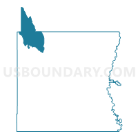
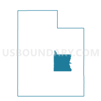
Huntington 921 Voting District, Emery County, Utah
About
Outline

Summary
| Unique Area Identifier | 678833 |
| Name | Huntington 921 Voting District |
| County | Emery County |
| State | Utah |
| Area (square miles) | 236.36 |
| Land Area (square miles) | 235.23 |
| Water Area (square miles) | 1.12 |
| % of Land Area | 99.53 |
| % of Water Area | 0.47 |
| Latitude of the Internal Point | 39.46318150 |
| Longtitude of the Internal Point | -111.10630930 |
Maps

Graphs
Select a template below for downloading or customizing gragh for Huntington 921 Voting District, Emery County, Utah


Neighbors
Neighoring Voting District (by Name) Neighboring Voting District on the Map
- Castle Dale 613 Voting District, Emery County, UT
- Castle Dale 715 Voting District, Emery County, UT
- Fairgrounds Voting District, Carbon County, UT
- Fairview Unincorporated 1 Voting District, Sanpete County, UT
- Fairview Unincorporated 2 Voting District, Sanpete County, UT
- Huntington 816 Voting District, Emery County, UT
- Huntington 818 Voting District, Emery County, UT
- Huntington 819 Voting District, Emery County, UT
- Huntington 920 Voting District, Emery County, UT
- Mount Pleasant Unincorporated 1 Voting District, Sanpete County, UT
- Orangeville 510 Voting District, Emery County, UT
- Sanpete Unassigned Voting District, Sanpete County, UT
- Scofield Unincorporated Voting District, Carbon County, UT
- South County Voting District, Carbon County, UT
Top 10 Neighboring County Subdivision (by Population) Neighboring County Subdivision on the Map
- Price CCD, Carbon County, UT (16,181)
- Mount Pleasant-Moroni CCD, Sanpete County, UT (11,400)
- Castle Dale-Huntington CCD, Emery County, UT (7,514)
- Helper CCD, Carbon County, UT (3,539)
Top 10 Neighboring Place (by Population) Neighboring Place on the Map
Top 10 Neighboring Unified School District (by Population) Neighboring Unified School District on the Map
- Carbon School District, UT (21,403)
- North Sanpete School District, UT (11,374)
- Emery School District, UT (10,976)
Top 10 Neighboring State Legislative District Lower Chamber (by Population) Neighboring State Legislative District Lower Chamber on the Map
- State House District 67, UT (42,669)
- State House District 70, UT (34,036)
- State House District 68, UT (31,934)
- State House District 69, UT (31,813)
Top 10 Neighboring State Legislative District Upper Chamber (by Population) Neighboring State Legislative District Upper Chamber on the Map
Top 10 Neighboring 111th Congressional District (by Population) Neighboring 111th Congressional District on the Map
Top 10 Neighboring Census Tract (by Population) Neighboring Census Tract on the Map
- Census Tract 9721, Sanpete County, UT (7,630)
- Census Tract 5, Carbon County, UT (4,248)
- Census Tract 9762, Emery County, UT (4,185)
- Census Tract 9763, Emery County, UT (3,329)
Top 10 Neighboring 5-Digit ZIP Code Tabulation Area (by Population) Neighboring 5-Digit ZIP Code Tabulation Area on the Map
- 84501, UT (13,612)
- 84526, UT (4,134)
- 84528, UT (2,742)
- 84513, UT (1,710)
- 84537, UT (1,505)
- 84518, UT (702)